Cost guides / 18-22 minutes / Aegis Project Planning Desk
Commercial Greenhouse Site Selection Guide: Land, Climate, Logistics and Due Diligence
Compare greenhouse sites before committing to land. Use a practical framework for parcel fit, climate exposure, logistics, due diligence and supplier-ready design inputs.
By Aegis Project Planning Desk
Published /Updated
Aegis supports commercial greenhouse owners with site-input planning, technology selection support, supplier coordination and project-management assistance. This resource is an educational planning guide and does not replace site-specific civil, structural, utility, legal or regulatory verification.
Decision support
Compare sites on usable area, not parcel size
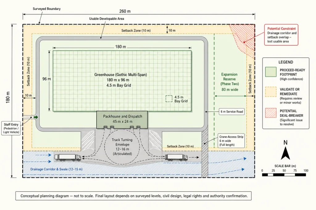
Test the area available after greenhouse footprint, roads, packhouse, drainage, setbacks and future phases. A 4.0-5.0 m bay layout can expose geometry constraints that gross land area hides.
Treat climate data as a design input
Verify minimum temperature, wind, snow, humidity and peak summer conditions before choosing a Venlo glass structure, Gothic multi-span frame, thermal screen strategy or cooling approach.
Do not tender before the evidence pack is complete
Issue the same surveyed boundary, climate basis, access assumptions and civil-interface notes to every supplier so omissions can be compared before they become change orders.
Key takeaways
- A low-cost parcel can become an expensive greenhouse site if usable geometry, drainage, access, legal certainty or climate exposure are weak. Screen candidate sites through four gates before committing to land: parcel fit, climate exposure, logistics and evidence-backed due diligence. Separate deal-breakers from remediable constraints before asking suppliers to quote. Convert validated site information into a supplier-ready design-input pack so quotations share the same assumptions and exclusions.
Market context
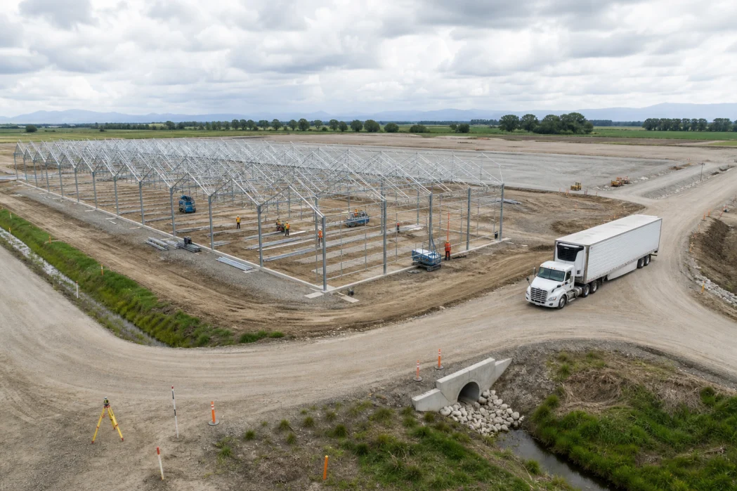
Commercial greenhouse site selection has become less forgiving because the land decision now fixes operational options long before a crop is planted. A parcel that appears close to market can still constrain a Gothic multi-span layout if heavy vehicles, drainage corridors and staff movements compete for the same entrance. The practical question is not whether a site has attractive features; it is whether its constraints leave a workable operating pattern after the greenhouse, packhouse and service circulation are placed.
Technology choice raises the consequence of an incomplete location assessment. A Venlo glass greenhouse with a 4.0–6.5 m ridge-height concept, a double-layer inflatable-film house, and an 8 mm twin-wall polycarbonate structure respond differently to wind exposure, winter temperature and summer humidity. Climate records therefore influence which design questions must be answered, rather than selecting a universally “best” structure. For the wider feasibility sequence and investment sensitivity, use the greenhouse investment guide.
Experienced owners separate signals from proof. A road visible on mapping, a neighbour’s statement about seasonal flooding, or a verbal assurance that services are nearby can justify further investigation, but none establishes access rights, drainage permission or connection capacity. That distinction protects the land decision: desktop findings help rank parcels, while surveyed, authority and provider evidence determines whether a promising parcel can proceed. Detailed validation of power, fuel, water, drainage and backup belongs in commercial greenhouse utility planning; source-water evidence should follow the greenhouse water quality requirements.
Commercial greenhouse site selection: use four gates before committing to land
A sound greenhouse location assessment is a sequence of decisions, not a checklist scored at the end. Test the parcel first, then its climate exposure, operating access and documentary certainty. A failure at an earlier gate can invalidate work completed later: there is little value in refining a 4.5 m bay Gothic multi-span layout if the surveyed boundary cannot accommodate drainage corridors, vehicle circulation or a lawful access route. For execution scope and commercial delivery structure, see commercial greenhouse project planning support.
Classify each finding as proceedpause for evidenceremediate and pricerenegotiate or reject. This prevents a desktop indication, a seller assurance or a supplier assumption from being mistaken for proof. Local authority, legal, survey, civil, geotechnical and structural confirmation remains site-specific; a screening result is not an approval or final design decision. For the matching structure platform, see hydroponic greenhouse system.
| Gate | Condition to test | Decision consequence | Evidence to obtain before moving on |
|---|---|---|---|
| 1. Usable parcel fit | Can a conceptual 4.0 m, 4.5 m or 5.0 m bay module fit with a packhouse, service yard, drainage route, setbacks and phase-two reserve? | Reject or renegotiate where gross area is adequate but the developable footprint is fragmented. A rectangular boundary commonly reduces road and gutter alignment conflicts; an irregular parcel may still work if lost corners do not constrain dispatch or expansion. | Licensed boundary and topographic survey, recorded easements, preliminary vehicle-sweep layout and written setback interpretation from the relevant authority. |
| 2. Climate exposure | Do temperature range, wind, snow, hail, humidity and solar records support a defensible design basis for the proposed Venlo glass or Gothic multi-span concept? | Pause where records are distant, incomplete or unrepresentative. Climate normals can guide early discussions, but they are not a structural load basis; wind and snow loads require application of the adopted local code by qualified professionals. | Historical station dataset with station distance and elevation noted, local extreme-event evidence, and an agreed preliminary structural design-load basis. |
| 3. Operating logistics | Can refrigerated dispatch, substrate delivery, staff vehicles and maintenance access operate without sharing a single constrained route? | Remediate only when turning space, road formation and delivery timing can be demonstrated. A site that accepts a passenger vehicle but not a loaded articulated vehicle can shift harvest flow into delay and handling risk. | Access-route review, vehicle-sweep test, road restriction records, dispatch-flow sketch and written confirmation of any third-party access rights. |
| 4. Legal-operational certainty | Are title, permitted use, easements, drainage rights and service claims evidenced rather than described verbally? | Pause or reject when a material restriction cannot be resolved in writing. Do not allow an unverified boundary, drainage discharge route or connection promise to enter a supplier brief as a fact. | Title and easement review, authority correspondence, drainage permissions where applicable, and provider correspondence. Use the commercial greenhouse utility planning guide for detailed service and backup validation. |
Apply a stop rule, not an average score
A high score for road proximity should not offset a missing legal right of access, just as a low-cost parcel should not offset unresolved flood routing. Treat title restrictions, unconfirmed permitted use, no viable drainage outfall, or a footprint that cannot support the intended 4.5 m bay alignment as potential stop conditions until evidence changes the finding. By contrast, a 1–2% operational grading difference, a relocatable service yard or additional internal road length may be correctable if survey and civil review can define the scope. For the crop-side planning logic, review lettuce greenhouse production.
The threshold changes with the operating model. A phased operation above 5 ha needs protected expansion geometry and independent construction access; otherwise phase two disrupts phase-one harvest flow. A smaller seasonal film house may accept a less efficient parcel if the route remains safe and the commercial programme does not depend on year-round dispatch. High-wire tomato production typically has less tolerance for compromised packhouse and refrigerated-truck circulation than a lower-volume leafy-greens programme. These are planning judgments, not universal land requirements. A more detailed benchmark sits in compare greenhouse technologies.
Do not advance a gate on verbal assurances
- Seller says access is available: verify the recorded right, road restrictions and vehicle geometry; a 16.5 m articulated vehicle needs a materially different turning test than a 7.5 m rigid truck.
- Climate data looks moderate: verify station representativeness, elevation difference and extreme-event history before a supplier selects structural loads or a 4.0–6.5 m ridge-height concept.
- Services are nearby: retain written provider evidence and direct detailed capacity, fuel, drainage and backup questions to commercial greenhouse utility planning; proximity is not a connection commitment.
- Water is present: record source, access rights and sampling status, then use the greenhouse water quality requirements guide for sampling and treatment decisions rather than assuming irrigation suitability.
The practical output of these gates is a short exception register: each unresolved item should name the evidence owner, the decision it blocks and the date by which it must be closed. Once no stop condition remains unowned, the site can move from greenhouse site feasibility screening to a controlled supplier-input brief. For the crop-side planning logic, review strawberry greenhouse production.
Cost and investment logic
The purchase price is not the decision metric. Compare each parcel by the cost certainty it creates after a conceptual 4.5 m bay layout, service circulation, packhouse position and drainage corridor are placed on the surveyed boundary. A cheaper irregular parcel can lose its advantage if it forces a fragmented Gothic multi-span footprint, additional retaining or an off-site dispatch workaround; a higher-priced rectangular parcel may reduce unknown interfaces and preserve a phase-two block. A scenario-level example of this decision path is shown in high-altitude vegetable greenhouse reference scenario.
Commit capital in evidence stages
Use a small, reversible spend to test a large, irreversible commitment. Desktop mapping can rank sites, but a purchase or long lease should wait until the items most likely to alter the usable footprint are evidenced: boundary and level survey, access constraints, drainage discharge route, title restrictions and authority feedback. For a 5 ha-plus phased operation, protecting a contiguous expansion zone can matter more than minimizing the first-phase land price; for a seasonal 0.5-1 ha operation, avoiding extensive cut-and-fill may deserve greater weight than future expansion.
- Proceed: Material constraints have a named owner, documented basis and a layout that retains operational circulation.
- Renegotiate: A remediable condition, such as a 2-4% local grade transition or road upgrade, is identifiable but the land terms do not yet reflect the added owner scope.
- Pause: The consequence may be material, but the survey, authority response or drainage evidence is incomplete.
- Reject: A restriction prevents the intended footprint, dispatch flow or expansion strategy and no credible remedy exists.
Keep the commercial comparison disciplined: ask whether the site changes scope, timing or flexibility—not whether it merely looks inexpensive. Use the commercial greenhouse cost guide to structure owner-scope and site-development allowances, and use the greenhouse investment guide when testing how those assumptions affect feasibility sensitivity. Neither replaces parcel-specific civil, legal or authority verification.
Technical considerations
Technical site review should convert a parcel into design constraints, not a generic checklist. For a multi-span greenhouse, test a conceptual 4.0 m, 4.5 m or 5.0 m bay grid against the surveyed boundary before selecting a footprint. The decision is whether the site still accommodates the production block, a packhouse edge, vehicle circulation, drainage corridors and a later phase without creating narrow, unproductive remnants. An irregular parcel can work, but only when its lost corners and access geometry do not force costly retaining, split operations or a compromised expansion line.
Translate terrain into buildability
A 1-2% finished-grade fall is often operationally convenient for surface-water routing around a Gothic multi-span frame; it is not a universal slope limit. Steeper terrain may remain viable where cut-and-fill quantities, retaining interfaces and a lawful discharge route can be defined, but the owner should pause where the topographic survey cannot establish levels across the greenhouse pad, service roads and outfall. Desktop elevation mapping is useful for screening; a surveyed datum is the basis for layout and civil decisions. A scenario-level example of this decision path is shown in desert cucumber greenhouse water scenario.
Use climate records to frame structural and envelope questions
For commercial greenhouse site selection, collect nearby station records for minimum winter temperature, peak summer temperature, wind direction and extremes, snow, hail, humidity and diurnal range. A 4.0-6.5 m ridge height changes the ventilation volume and crop-clearance options, while the same weather record can lead to different concept questions for a Venlo greenhouse, double-layer inflatable film, or 8 mm twin-wall polycarbonate. Glass generally prioritizes light transmission, whereas insulated film or polycarbonate may reduce heat loss at the cost of different light, durability and structural considerations. Structural wind and snow loads must be set by the applicable local code and project-specific engineer; climate normals are not a substitute for that design basis.
Check drainage and soil evidence at the footprint, not only at the parcel boundary
Review contour levels, mapped flood evidence, visible flow paths, culverts and the proposed stormwater discharge route across the actual building zone. A hot-dip galvanized steel structure can tolerate a well-designed drainage environment, but persistent ponding beside foundations, crop aisles or loading areas raises corrosion, access and hygiene risk. Mapped soils can identify where boreholes or geotechnical review are warranted; they cannot confirm bearing conditions, settlement behavior or earthworks quantities. Where drainage crosses third-party land or a public channel, obtain written rights and authority guidance before treating the route as available.
Test operational traffic as a physical layout constraint
Run separate swept-path checks for refrigerated dispatch, substrate deliveries, fertilizer handling and staff vehicles. A 12-16 m articulated vehicle needs substantially different turning and loading space than a rigid local truck, so road distance alone is a weak logistics measure. Locate the packhouse and dispatch apron so harvest movement does not cross incoming-material traffic; this becomes more important for high-throughput crops such as a tomato greenhouse than for a smaller seasonal block. If the route includes weight, height or time-of-day restrictions, confirm them in writing rather than relying on a broker or landowner statement.
Keep utility and water evidence separate from site impressions
Record proposed connection points, route lengths, easements and written provider responses, but do not assume that a nearby line establishes usable capacity. Detailed validation of electrical demand, fuel, water, drainage and backup interfaces belongs in commercial greenhouse utility planning. Likewise, a borehole or canal visible on site is not a water-quality finding: collect a representative source sample and use the greenhouse water-quality requirements guide to define the sampling evidence needed before a hydroponic or fertigation concept is fixed.
Technical evidence to release before concept design
| Design input | Minimum decision use | What to verify next |
|---|---|---|
| Boundary and topographic survey | Tests 4.0-5.0 m bay alignment, pad levels, roads and phase-two space. | Coordinate reference system, easements, setbacks and surveyed elevations. |
| Climate record and site exposure notes | Frames ridge-height, ventilation, cladding and structural-load questions. | Applicable local wind, snow, hail and code design basis. |
| Drainage and ground evidence | Identifies ponding, retaining, outfall and foundation-investigation risk. | Hydrology, geotechnical scope and discharge permissions where material. |
| Vehicle-flow drawing | Tests dispatch separation, crane approach and 12-16 m truck movements. | Road restrictions, turning geometry and seasonal access reliability. |
Common land-commitment mistakes
Most weak site decisions are not caused by one dramatic flaw; they come from treating an early desktop impression as proof. For a Gothic multi-span layout using 4.5 m bays, a small boundary irregularity, drainage corridor or access pinch point can remove an entire run of bays and disrupt packhouse flow. Treat each finding as either a verified fact, an unverified assumption or a constraint requiring a specialist response.
Buying gross hectares instead of usable developable area
A parcel may look generous on a sales plan but become constrained once the greenhouse footprint, service roads, turning space, setbacks, drainage routes and a phase-two reserve are drawn against a surveyed boundary. Test a conceptual 4.0 m, 4.5 m and 5.0 m bay arrangement before negotiating price; the best land is often the parcel that preserves clean expansion geometry, not the one with the largest headline area.
Accepting verbal assurances as site evidence
Statements that a road can take refrigerated vehicles, a utility connection is available or an outfall is acceptable are not a design basis. Obtain written provider, road-authority and land-right evidence, then route capacity and backup questions through commercial greenhouse utility planning. For irrigation sources, collect a representative sample before commitment and use the greenhouse water-quality requirements guide to define the required sampling scope.
Using climate normals as structural design loads
A monthly average does not establish the wind, snow, hail or temperature basis for a Venlo glass structure or a Gothic multi-span film structure. A 4.0-6.5 m ridge-height concept, for example, changes wind exposure, ventilation volume and heating demand, but the applicable wind and snow loads remain jurisdiction- and site-specific. Ask the structural designer to confirm the adopted code, exposure assumptions and load basis before treating a supplier concept as buildable.
Assuming drainage is solved because the land looks flat
Flat ground can hold water when finished levels, culverts or discharge rights are unresolved; steep ground can be manageable but may introduce retaining, cut-and-fill and road-grade complexity. A 1-2% operational grading concept is a useful early planning reference, not a universal limit. Verify surveyed levels, upstream catchment, flood history and the lawful drainage route before relying on a conceptual layout.
Choosing the cheapest parcel without testing operating friction
A lower acquisition price can be outweighed by daily conflicts between staff vehicles, substrate deliveries, harvest transfer and refrigerated dispatch. Run a vehicle-sweep review using the actual delivery vehicle class and test whether the packhouse can sit on the short side of a 4.5 m-bay greenhouse block without forcing harvest traffic across loading movements. If the operating model is still uncertain, review its wider sensitivity in the greenhouse investment guide rather than assuming land savings are automatically project savings.
Delaying evidence collection until after the deal is signed
Title restrictions, easements, planning conditions and survey discrepancies are far easier to renegotiate before a purchase or lease is binding. Record coordinates, boundary datum, topographic survey, access constraints and known climate exposures in one controlled file. That discipline also prevents owner-side site-development items from being mistaken for greenhouse supply scope; use the commercial greenhouse cost guide when assessing those owner-side allowances.
Validate the Site Before It Becomes a Quotation Exclusion
Before requesting supplier quotations, assemble the candidate-site boundary, topographic survey, intended crop, phase-one area, access notes, climate record summary and any planning or title evidence already available. The useful outcome is not a generic site opinion; it is a clear list of verified inputs, unresolved items and named owners for each remaining check.
Aegis can support an initial feasibility review and prepare a supplier-ready site-input brief for commercial greenhouse projects. This is most useful when a purchase, lease or land-shortlist decision is approaching and suppliers would otherwise make different assumptions about a 4.5 m bay layout, drainage interfaces, vehicle access or the local wind-and-snow design basis.
Request a Greenhouse Site Feasibility Review with your available site information, or use commercial greenhouse consulting support to structure the next validation steps. Final land, civil, structural, utility, legal and authority decisions remain subject to site-specific professional and jurisdictional verification.
FAQ
Frequently asked questions
How much land is needed for a commercial greenhouse?+
Start with usable developable area, not gross hectares. A conceptual Gothic multi-span layout using 4.0 m, 4.5 m or 5.0 m bays should fit alongside the packhouse, truck circulation, drainage corridors, required setbacks and a phase-two reserve. The correct parcel size therefore depends on the crop programme and operating flow; a surveyed boundary and preliminary layout are more reliable than a simple greenhouse-to-land ratio.
What makes a greenhouse site unsuitable before design begins?+
Pause or reject a parcel when a material constraint has no credible route to resolution: unclear title or easements, unconfirmed permitted use, no lawful drainage outfall, access that cannot accommodate refrigerated dispatch, or flood and climate-load exposure that remains unverified. A 1–2% operational grading concept may be manageable in early planning, but steeper terrain can introduce retaining, cut-and-fill and stormwater interfaces that require a site-specific civil review before commitment.
What climate information should be collected for greenhouse site feasibility?+
Collect representative historical records for minimum and peak temperatures, wind, snow, hail, humidity, solar radiation and diurnal variation. These inputs affect whether a Venlo glass structure, Gothic multi-span frame, double-layer inflatable film or 8 mm twin-wall polycarbonate concept is worth evaluating, as well as ridge-height, ventilation and woven energy-screen assumptions. Climate normals are useful screening evidence; local code adoption and a qualified structural design basis determine wind and snow loads.
Should a greenhouse supplier assess the site before issuing a quotation?+
Suppliers can price a more comparable concept when they receive the same evidence pack, but their preliminary review does not replace a licensed survey, authority confirmation or civil and structural investigation. Issue coordinates, boundary and level data, access drawings, climate basis, drainage constraints and known easements to every bidder. For power, fuel, drainage, backup and connection-boundary evidence, use this commercial greenhouse utility planning guide before treating a verbal availability statement as a design input.
What documents belong in greenhouse site due diligence?+
Collect title and easement records, written planning or zoning correspondence, a topographic survey, flood and drainage evidence, geotechnical scope where formation conditions are uncertain, climate records, vehicle-access information and written utility-provider responses. Obtain source-water sampling before selecting irrigation or treatment equipment; the required sampling evidence is covered in the greenhouse water quality requirements guide. Desktop maps can screen a site, but they do not validate construction levels, bearing conditions or discharge rights.
How should two potential greenhouse sites be compared?+
Score both parcels against the same decision criteria: legal certainty, usable geometry, drainage exposure, climate consequences, logistics, service evidence, expansion capacity and remediation burden. Change the weighting to match the operating model: a phased 5 ha-plus project may give greater weight to expansion and resilient access, while a first seasonal phase may prioritize low civil complexity. Record the evidence behind each score; an attractive total score is not a proceed decision if a high-impact legal or hydrology item remains unverified.
Validate the site assumptions before they become quotation exclusions
Share your candidate-site boundary, target crop, planned greenhouse area and available due-diligence documents. Aegis can help frame the missing validation items and prepare an initial supplier-ready site-input brief.